Details
Deutschlanndt
A Map of Deutschland, Germany, compiled by Franciscus Hogenberg, in the year 1576 from Cologne of the Ubii].
(Cartouche bottom right corner:) Magnifico, Nobili, ac Præcellentj viro ac Do:|mino, D. Constantino a Lijskirchen, florentis:|simæ Agrippinensis Reipub. Consuli Seni:|ori, Franciscus Hogenbergius nuncupat. [Dedicated] to the magnificent, noble and very excellent man and lord D. Constantinus of Lijskirchen, Senior Councillor of the most flourishing Cologne republic, by Franciscus Hogenberg].
Plate size: 381 x 490 mm
Scale: 1 : 3,000,000
Reference: Ort 57.1 = first state before the stippling behind 'Oceanus...)
(Koeman/Meurer: 147, not in Karrow, van der Krogt AN: 2000:31B).
Occurrence in Theatrum editions from 1602 untill 1609
Approximate number of copies printed: 1775.
Here in first state: 57.1 as described.
(57.2: in 1606 ->the sea behind "OCEANVS GER|MANICVS" received stippling.)
(57.3: after 1612 ->, we find below the cartouche and above the privilege "Theodorus Galle excudit Antuerpiæ", with Spanish text on verso)
Cartographic sources: Frans Hogenberg (1538-1590), who engraved many of the plates for the Theatrum, produced in 1576 a single sheet map of Germany which was published in Cologne. Possibly, some Theatrum copies earlier than 1603 also contain this map (Meurer p. 169-170).
References: P.H. Meurer: "Abraham Ortelius' Concept and Map of 'Germania'", p. 263-270 in M. van den Broecke, P. van der Krogt and P.H. Meurer (eds) "Abraham Ortelius and the First Atlas", HES Publishers, 1998.
Additional Information
| SKU | xxmam52 |
|---|---|
| Picture Size | 38,10 x 49 cm |
| Specification | Map |
| technic | Engraving |
| Artist | Abraham Ortelius |
| period | 16th Century |
| School | Flemish |
| subject | Other |
| rating | **** |
Abraham Ortelius (1527-1598)
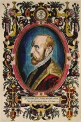 Flemish geographer and cartographer, born in Antwerp on April 14, 1527. He studied Greek, Latin and mathematics in Antwerp and worked as a map and book dealer. He also spent time with cartography and published the first world atlas, "Theatrum Orbis Terrarum", which was probably the first collection of maps in the shape of a book, 20 years before Mercator published his world atlas.
In its time, "Theatrum Orbis Terrarum" was so successful, that it had to be re-printed 4 times in the first year of its publishing alone. Between 1570 and 1612 the atlas was published in 42 editions and the 7 languages Latin, German, Flemish, French, Spanish, English and Italian. It proved to be an enormous success for Abraham Ortelius and his beneficiaries.
Abraham Ortelius was the first cartographer, who named the sources of his maps by mentioning the cartographers. Any subsequent editions after 1598 were published by Jan Baptiste Vrients, who purchased the rights after the death of Abraham Ortelius and his beneficiaries. Abraham Ortelius also produced a collection of place names "Thesaurus Geographicus", which is of similar importance. Abraham Ortelius died in 1598.
All the items are guaranteed to be originals and as described.
A letter of authenticity is added by simple request.
Items may be returned within 15 days after arrival.
I ship worldwide and provide Insurance and other delivery options.
All items can be purchased instantly at the listed prices,
on reservation of errors in price or availibility..

 Facebook
 Twitter
 Subscribe us
 Flickr


