-
 $320.00
 -
 $800.00
 -
 $100.00
 -
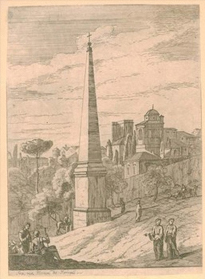
 Price: On Request
 -
 $600.00
Details
“Poitov. Pictonum Vicinarum que Regionum Fidiss Descriptio".
Copper etching by Petro Rogiero
Published in “Theatrum Orbis Terrarum" by Abraham Ortelius (1528 - 1598).
The map is dated inside the plate 1579.
Title: POICTOV. (cartouche upper right:) PICTONVM | VICINARVM:|QVE REGIO:|NVM FIDISS | DESCRIPTIO. | "Auctore | Nobili Dño Petro Rogiero | Pictone, Regiæ Mtis Galliæ | consiliario, etc". [A very true depiction of Poictou and neighbouring regions by the noble Petrus Rogierus from Poictou, counsellor of the Majesty of France] (top right of middle:) "Cum Imp. et Regie Mts | priuilegio ad decennium. | 1579". [With Imperial and Royal privilege for ten years. 1579]
Plate size: 365 x 504 mm
Scale: 1 : 600,000 Identification number: Ort 38 (Koeman/Meurer: 75, Karrow: 1/110, van der Krogt AN: 4500:31).
The map was part of the Theatrum from 1579 through 1609.
The one I sell here is from the 1598 edition as described by Koeman.
1598 French edition with page number 28 on the back (525 copies printed) (last line, left aligned: la Cosmographie de Theuet.)
All editions together some 6675 copies were printed.
Beautiful antique map of the former French province of Poitou, with the city of Poitiers in the center, reaching from the Atlantic to La Haye and Limoges and from Nantes to Cognac and the run of the rivers La Charente and Taurion. Very nicely showing Ile de Re and Ile d'Oleron. Very attractive original hand coloring of this map. Wide margins.Very good impression. Three decorative cartouches. In general a very nice, attractive antique map.
Additional Information
| SKU | xxmam53 |
|---|---|
| Picture Size | 36 x 50,50 cm |
| Specification | Map |
| technic | Engraving |
| Artist | Abraham Ortelius |
| period | 16th Century |
| School | Flemish |
| subject | Other |
| rating | *** |
Abraham Ortelius (1527-1598)
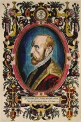 Flemish geographer and cartographer, born in Antwerp on April 14, 1527. He studied Greek, Latin and mathematics in Antwerp and worked as a map and book dealer. He also spent time with cartography and published the first world atlas, "Theatrum Orbis Terrarum", which was probably the first collection of maps in the shape of a book, 20 years before Mercator published his world atlas.
In its time, "Theatrum Orbis Terrarum" was so successful, that it had to be re-printed 4 times in the first year of its publishing alone. Between 1570 and 1612 the atlas was published in 42 editions and the 7 languages Latin, German, Flemish, French, Spanish, English and Italian. It proved to be an enormous success for Abraham Ortelius and his beneficiaries.
Abraham Ortelius was the first cartographer, who named the sources of his maps by mentioning the cartographers. Any subsequent editions after 1598 were published by Jan Baptiste Vrients, who purchased the rights after the death of Abraham Ortelius and his beneficiaries. Abraham Ortelius also produced a collection of place names "Thesaurus Geographicus", which is of similar importance. Abraham Ortelius died in 1598.
All the items are guaranteed to be originals and as described.
A letter of authenticity is added by simple request.
Items may be returned within 15 days after arrival.
I ship worldwide and provide Insurance and other delivery options.
All items can be purchased instantly at the listed prices,
on reservation of errors in price or availibility..


 Facebook
 Twitter
 Subscribe us
 Flickr


