-
 $1,400.00
 -
 $1,400.00
 -
 $1,200.00
 -
 Price: On Request
 -
 $120.00
Details
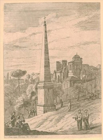
Provinciae
Probably from the 1606 edition with the French text
Detailed map of the Province prepared by Pierre-Jean de Bompar who published a single sheet map of the Province in 1591.
Title cartouche on the upper left-hand corner. Engraved by Baptista Doetecom.
Original color with the green setting of on the backsidfe as should be.
Additional Information
| SKU | xxbt10 |
|---|---|
| Picture Size | 35,60 x 51 cm |
| Specification | Map |
| technic | Engraving |
| Artist | Gerard Mercator |
| period | 17th century |
| School | Flemish |
| subject | Other |
| rating | **** |
Gerard Mercator (1512 – 1594)
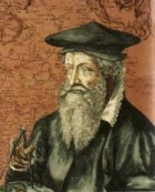 Mercator is a seminal figure in the history of cartography. Mercator's calculations and map designs redefined the 16th century concept of cartography and were the first to break away from the Ptolemy model. Many of his systems of measurement, such as the Mercator Projection, are still in use today. Despite his prominence as a cartographer, he started his career as a crafter of scientific instruments.
He did not construct his first map until 1540, when he made two maps, one of Flanders and another of Palestine. These two impressive works earned him the patronage of the Emperor Charles V, for whom he construed a globe and several large scale maps. Despite this imperial patronage, Mercator was accused of heresy and in 1552 fled to Duisburg. In Duisburg he set himself up as a cartographer and began work on his revised edition of Ptolemy's Geographia. This three volume work was the first book to be called an "Atlas", after the Titan and King of Mauritania. F
ollowing Mercator's death his descendants took over his firm but languished because of heavy competition from the Ortelius firm. It was not until Mercator's plates were purchased and republished ( Mercator / Hondius ) by Henricus Hondius and Jan Jansson that Mercator's position as the preeminent cartographer of the age was re-established
All the items are guaranteed to be originals and as described.
A letter of authenticity is added by simple request.
Items may be returned within 15 days after arrival.
I ship worldwide and provide Insurance and other delivery options.
All items can be purchased instantly at the listed prices,
on reservation of errors in price or availibility..


 Facebook
 Twitter
 Subscribe us
 Flickr


